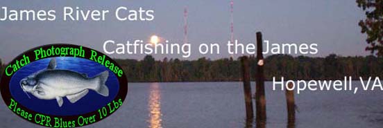
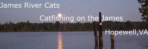
James River
Catfishing
|
The James has
me hooked and
to me it's
nothing like
being on the
James not only
the fishing
but just the
river itself,
the beauty,
wildlife and
history of the
James just
holds me in
ah. I've seen
some of the
most beautiful
sunsets while
fishing on the
James that you
could see
anywhere
.
A word of
caution, the
river is
constanly
changing. Many
of the flats
on the James
extend out
futher than
the charts may
indicate.
One of the
first
things to
understand
is the
buoy
markers on
the river
in the
main
channel
and
staying
between
the red
&
green
buoys when
traveling
the river.
The 3 Rs
can be a
good
start:
-
Red
: red
buoy
-
Right
: the red
buoy on
your
right
-
Returning
: if the
red buoy
is on your
right side
you are
returning
from the
sea...coast....
|
The second thing to
remember is respect the
river....it can get ugly
fast. Read the about the
close calls these guys had
on the last half of the
linked
page:
The third is
getting familiar with
the river.....If you
click on this link and
study the river from
the map link it will
help you get more
familiar with the
river:
The below link is ONLY for
the purpose of pointing
out locations along the
James and getting familiar
with the James River in VA
from Richmond to Hog
Island about a 70 mile
stretch of the river. If
you have Goggle Earth
loaded you can click the
link at the top of the
page to view it
through
that.
All the links to the river
locations are under the
paragraph explaining the
map.
You will also notice I
have the ramps in order as
you are going down river
from Richmond at the top
of the chart, any ramp you
click on will also have a
link to get directions.
Also after the ramp
listings, all areas on the
map are in order coming
down river. Just like
you're GPS/fishfinder you
can zoom in and out on the
map. A larger view of the
map is aquired by clicking
the double arrow at the
top left hand side of the
map. I think it's a great
tool for learning the
river and wish I would
have had it when I was new
to the
James.
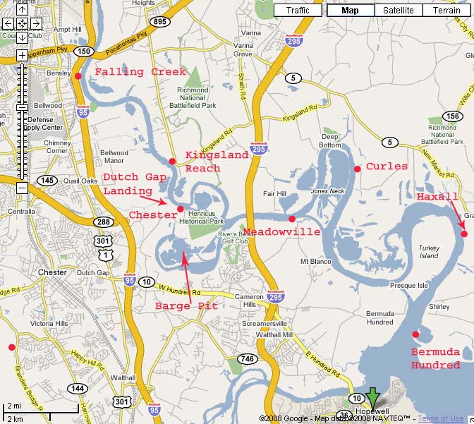
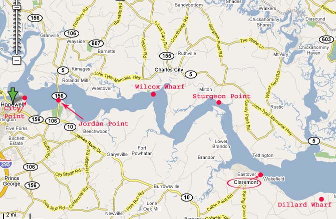
When clicking on the
pointers for each area on
the James many of the
popup windows also have
links, especially the
ramps (1-10). When the map
first comes up it's a good
idea to zoom in a little
so the pointers are spread
out. "L" 295
bridge is pretty neat, a
link is in the popup for a
pic from a plane. At the
top left corner of the pic
is Dutch Gap Power
Plant.
Also
t
hese are the
best charts I've
found. I actually
printed them out and
carry them in a 3 ring
binder when I go
fishing. I also use
top loading sheet
protectors rather than
punching holes, plus
it keeps the pages
dry.
These
are large files so be
patient it may take a
minute or so if you
have a slow internet
connection. I would
recommend saving the
file to your computer.
After the file is
loaded just click on
file on the top menu
and then save and
choose the location on
your computer to save
it. These files are in
PDF format
and what is great you
can zoom in to look at
details.
Below is the Booklet
Form
(Note: If you have a
dial up connection
don't even try......it
takes a while even on
broadband)
Below are links to view
the James River Charts
that are complete...not
broken down into
pages:
Can someone give me an
idea where to
start?
Think
about safety when
boating......it could save
your
life
.
..
guide
your first trip to the
James River to get
somewhat familiar with the
river. I have even heard
of guides from other areas
that will use a guide the
first time on the James.
Being a tidal river, of
course you have to keep
tabs on the tide, the
wind, shallows, and barges
to mention just a few
things. The barges and
cargo ships can be
unbelievable quiet to be
as large as they are and
can sneak up on you when
you least expect
them.
Caution around Hopewell,
Benjamin Harrison Bridge
and the Islands before Tar
Bay is critical. Getting
out of the main channel
has its risk, shallow
water and wrecks are 2
things to be careful of.
Keeping in mind the James
is a tidal river the water
level can change as much
as 3 feet so it's very
important to keep up with
what the tide is doing
especially if you are out
of the main
channel. The average
depth of the main channel
is between 20 & 30'
(not to say there is a lot
of 40, 50, 60, and even 90
foot deep areas on
the James)and you can get
in a foot of water real
quick out of the main
channel in some areas
and especially around
Hopewell.
Always keep in mind the
barge and ship traffic and
highly recommend anchoring
on the edge of the main
channel and it still can
be close on some of the
cut-thru areas especially
Presque when a large barge
or container ship comes
through.
The best way to start is
studying
charts and
maps
.
The
below linked software is
free but takes a lot of
memory on the computer to
run it.
You will need
Google Earth
Software
loaded
first for EarthNC to
run.
EarthNC
-
N
autical Data for a Digital
World . You might need to
already have
Google Earth
Software
loaded and running
before using
EarthNC. It's great
if you have every used
Google Earth this is an
added bonus. Great
tool for the James River.
2 files, scroll down
the VA
listings:
-
US5VA32M(12252)
James River, Jordan
Point to
Richmond
-
US5VA51M(12251)
James River, Jamestown
Island to Jordan
Point
Would Hopewell be a
good area to
start?
Several things you need to
consider on the James. It
can get rough on the water
fast if the wind starts
bucking the tide. So you
have to consider your boat
size and the area you plan
to fish, it can be calm
when going out and then in
the afternoon the wind
could make it a real
danger getting back in.
Hopewell and below is
considered big water and
can be the biggest threat
in a smaller boat. Check
out this link on my site
scroll on down below the
weather links to read
about some experiences
from others:
http://www.jamesrivercats.com/weather.htm
But I"m not sure guess I
will bring my own bait for
the first day but gonna
need to catch it the next
day. I'm sure they will be
deep during the cold
weather and you probably
can catch some around the
banks at night or in the
mornings.
Before day break and the
last 2 hours of outgoing
tide is the very best time
to catch bait but not
always able to catch that
combination. But you are
right if you can get out
before day break. During
the day, it's much easier
to catch bait the last 2
hours of outgoing tide, on
high tide the bait is
scattered. Most guys use
gill nets on the James for
bait in which you have to
acquire a
separate license
other than a fishing
license. Many guys catch
bait around the Benjamin
Harrison Bridge
area.
Here are 2 links from my
website on
bait
http://www.jamesrivercats.com/gill.htm
http://www.jamesrivercats.com/bait_fish.htm
Also let me mention if you
are not
after altogether
trophy size blue cats eel
makes an great bait and
would keep your son more
interested as
usually you will
bring more fish in the
boat just smaller. Eels
will bring a lot of the
smaller size fish to the
boat, fish them live or in
4" chunks. Fishing them
live cut off 4" from the
tail and hook them at the
cut. Run the hook from the
inside meat at the cut
then through the tough
skin...makes it a little
easier. If you hook
the head they will wrap
around the
leader.
http://www.jamesrivercats.com/bait.htm
A couple places to get
eels:
CASTAWAY'S SPORTING
GOODS
11600 Jefferson Davis
Highway,
Chester, VA
23834
Map
-
Winter
Hours-
-
Mon-Thur:6:30 -
6:00,
-
Fri & Sat: 6:30 -
7,
-
Sun: 6:30 -
4:00
2570 New Market Road
Richmond VA
23231
Map
-
M-S
7am-5pm
-
Sunday
7am-2pm
-
Around 1.3 miles
from 295
(Exit 22B) on
Route 5 W on the
right.
-
Live
Eels
-
Up to 10 oz. disc
sinkers
Phone:
804-795-5917
Also what lb leader do
most use. I use 65 lb
powerpro and sometimes
mono leader but not sure
on the James
River?
WELL....I have used
a guide to get familiar
with the James, he has
fished the James for the
past 38 years and doesn't
like braided line at all.
He says it will break
easer than mono and I
think I would have to go
along with that. Just in
tying knots I have found
the braided line will
break much easier than
mono when using pliers to
snug the tag line on the
knot. The mono leader
absorbs the shock of
sudden jerks and runs from
the catfish, and gives the
quality of abrasion
resistance not found in
braid. I have seen
30 lb test snapped into
like it's nothing. My
preference is at least a
40 lb mono test line with
a 80 lb test leader, with
the leader length ranging
from 12-30 inches long.
The link below has more
info on
tackle:
http://www.jamesrivercats.com/tackle.htm
Is there alot of
snag, stumps
etc?
Snags and stumps are
usually not a problem
although you can find some
areas to be a pain. If you
fish really close to the
old wrecks and barges you
can get hung up also. The
Presque cut area again is
a problem area for losing
anchors because of the
rocky
bottom.
Also a lot of great info
in my
links to articles section
on the
website
.
The first pic below will
have some general fishing
areas with red dots that
most guys know about, what
most would call community
holes. Its a good start
for general
info.
Click on on chart
below for full
view...
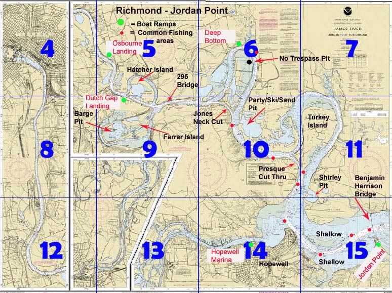
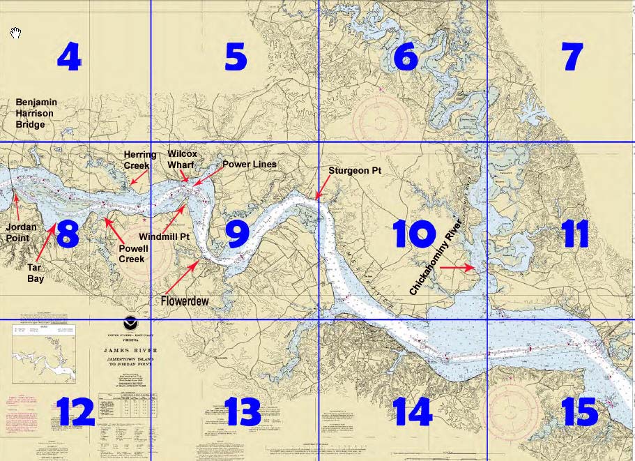
How Far is
it?
1. Osborne Landing
to upper leg Jones
neck: 4.75
miles
(upper
Deep Bottom
Leg)
2. Osborne Landing
to Dutch Gap Ramp:
1.6
miles
3. Osborne Landing
to Jimmy Dean's:
2.1
miles
4. Osborne Landing
to 895 Bridge: 4.6
miles
5. Jones Neck Cut
(distance from
upper to lower
leg) : 1
mile
6. 295 Bridge to
upper leg Jones
neck (upper Deep
Bottom Leg): 1.32
miles
7. Deep Bottom
Ramp (upper leg)
to Main River
Channel: 2.2
miles
8. Deep Bottom
Ramp (lower leg)
to Main River
Channel: 2.9
miles
9. Deep Bottom
Ramp (upper leg)
to inside Barge
Pit: 6.5 miles
10. Deep Bottom
Ramp to mouth of
Appomattox: 7.7
miles
11. Deep Bottom
Ramp to Jordan
Point : 11.7
miles
12. Jordan Point
to Wilcox
Warf/Power Lines:
7.7
miles
13. Jordan Point
to Wards Creek: 12
miles
14. Wards Creek to
Sturgeon Point:
4.5
miles
15. Wards Creek to
Mouth of Chick: 14
miles
16. Mouth of Chick
to HWY 5 Bridge: 2
miles
17. Mouth of Chick
to Upper
Chippokes: 4.6
miles
18. Mouth of Chick
to College Creek:
14.5
mile
s
19. HWY 5 Bridge
to Morris Creek
Ramp: 3.5
miles
20. HWY 5 Bridge
to Brickyard: 8
miles
21. HWY 5 Bridge
to Rivers Rest:
11.7
miles
|
Notice: Gill Net
License News from
DGIF:
A
ll the saltwater
licenses presented in
our purchasing systems
are VMRC license and
DGIF provides the
service of selling
them as an agent. A
link below to VMRC
showing "What's New"
showing the six
recreational license
that DGIF is now
selling for them
through our system.
Customers can contact
us at 866-721-6911 for
replacements or
corrections on any of
the licenses we
sell.
DGIF's system is
completely automated,
customers purchasing
via DGIF will be able
to purchase the VMRC's
2010 license on
01/01/2010.
3 ways in which to
purchase licenses
through DGIF, link
below:
http://www.dgif.virginia.gov/licenses
/
For further
assistance, contact
DGIF at
866-721-6911.
VMRC link
below:
http://www.mrc.virginia.gov/whatsnew.shtm
July 2, 2009: Six
Virginia Marine
Resources Commission
licenses for
recreational use of
some commercial
fishing gear now will
be available for
purchase through the
Virginia Department of
Game and Inland
Fisheries' easy-to-use
online or
over-the-phone license
sales system.
Available for purchase
for recreational use
will be licenses for
fish cast net, fish
dip net, crab
trotline, 300-foot
gill net, eel pots and
a crab pot license
that allows up to five
pots to be set
recreationally. These
licenses now can be
purchased online at
Licenses, by calling
1-866-721-6911 (Monday
through Friday from 8
a.m. to 5 p.m., except
holidays) or in person
from hundreds of DGIF
license agents located
around the state.
Licenses are also sold
by some clerks of the
Circuit Court, or
through mail order.
The licenses will
continue to be sold by
VMRC licensing agents
as well.
 |