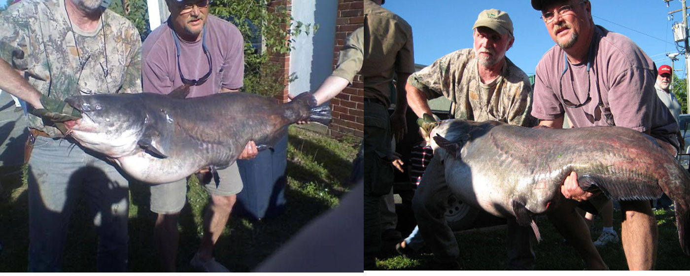
The blue catfish population continuing to expand, both in numbers and in size, enhances the possibility of your catch of a lifetime.
See More Details...
James River Catfishing
The thing with the James you can get in shallow water real quick...in fact I noticed one of the guides carries a 1.5 dia x 20' long push pole on his boat just in case he gets hung up and he has been fishing the James 38 Years. I went to Lowes and bought a closet dowel that is 1.5 dia and 12 foot long I now carry on my boat.
If you are going to the James for the first time it never hurts to hire a guide to get somewhat a feel for the river. I had studied the maps & charts quit a bit and still was surprised to to be somewhat disorientated my first trip.
Marked Charts/Maps below: This is not for navigation. Proper tools for navigation are needed such as charts and a GPS which will help inform one of the hazards on the river. The first link below is an active Google map and the location points are in order starting near Richmond and proceeds down river to Hog Island. On the left hand side all of the locations are listed starting with the ramps/landings in order as you travel down river, then next, points of interest are listed in order. If the list is clicked on in order it may help in getting familiar with the James River.The list is under the introduction and is not visible until scrolling down. Also the map itself would need to be zoomed in somewhat.
Now just like a marine GPS you have to zoom in and out to use the full potential of the map and understand where your position is. The zoom is much quicker and easier if you have a wheel mouse. Also the hand grab is much faster to navigate with.....just press the left button on the mouse and hold it down and the move the mouse left, right, up, or down.
One neat thing is on the left hand side you can just click on a location and Google will spot you there on the map
Getting out of the main channel has its risk, shallow water and wrecks are 2 things to be careful of. The changing tide, wind, and the barge traffic along the James are other factors that need to be considered.
This is ONLY for the purpose of pointing out locations along the James and getting familiar with the James River in VA from Richmond to Hog Island about a 70 mile stretch of the river.Lower James River--Google Maps--Richmond to Hog Island
Tide Points on the James River--Richmond to Hopewell
Tide Points on the James River--Hopewell to the Chickahominy River
Marked up Google Map.
James River Map (Garmin)
i-Boating : Free Marine Navigation Charts & Fishing Maps
The online chart viewer requires javascript. Once enabled you can view lake depth contour maps, electronic navigation charts (ENCs) in your browser. ... Marine ...
Best Fishing For Blue Catfish In The State
How Far is it?
1. Osborne Landing to upper leg Jones neck: 4.75 miles
(upper Deep Bottom Leg)
2. Osborne Landing to Dutch Gap Ramp: 1.6 miles
3. Osborne Landing to Jimmy Dean's: 2.1 miles
4. Osborne Landing to 895 Bridge: 4.6 miles
5. Osborne Landing to I 95 Bridge (downtown Richmond): 10.5 miles
6. Jones Neck Cut (distance from upper to lower leg) : 1 mile
7. 295 Bridge to upper leg Jones neck (upper Deep Bottom Leg): 1.32 miles
8. Deep Bottom Ramp (upper leg) to Main River Channel: 2.2 miles
9. Deep Bottom Ramp (lower leg) to Main River Channel: 2.9 miles
10. Deep Bottom Ramp (upper leg) to inside Barge Pit: 6.5 miles
11. Deep Bottom Ramp to mouth of Appomattox: 7.7 miles
12. Deep Bottom Ramp to Jordan Point : 11.7 miles
13. Jordan Point to Wilcox Warf/Power Lines: 7.7 miles
14. Jordan Point to Wards Creek: 12 miles
15. Jordan Point to Upper Chippokes: 21 miles
16. Wards Creek to Sturgeon Point: 4.5 miles
17. Wards Creek to Mouth of Chick: 14 miles
18. Mouth of Chick to HWY 5 Bridge: 2 miles
19. Mouth of Chick to Upper Chippokes: 4.6 miles
20. Mouth of Chick to College Creek: 14.5 miles
21. HWY 5 Bridge to Morris Creek Ramp: 3.5 miles
22. HWY 5 Bridge to Brickyard: 8 miles
23. HWY 5 Bridge to Rivers Rest: 11.7 miles